

Borders are usually easy to understand. A line on a map separates one country from another, and crossing it often means passing through immigration, customs or at least a clearly marked checkpoint. But in one small European town, the border is nothing like that.
In Baarle, Belgium and the Netherlands are so intricately intertwined that the international boundary passes through streets, gardens, businesses and even houses. A person can walk from one country into another in just a few steps and sometimes without even realizing it.
A Town Divided Between Two Countries
Baarle is made up of two municipalities: Baarle-Hertog, which belongs to Belgium, and Baarle-Nassau, which belongs to the Netherlands. What makes the town extraordinary is not simply that two countries meet there. Instead, their territories are broken into numerous pieces that fit into one another like a geographical puzzle.
There are 30 enclaves in the Baarle area: 22 Belgian enclaves belonging to Baarle-Hertog and eight Dutch enclaves belonging to Baarle-Nassau. The Belgian enclaves are surrounded by Dutch territory, while seven of the Dutch enclaves are actually located inside two of the larger Belgian enclaves.
This creates an unusual situation known as counter-enclaves essentially, pieces of one country sitting inside another country’s enclave. It is one of the most complicated examples of international borders anywhere in the world.
Link: (Visit Baarle)
The Border Doesn’t Follow a Straight Line
When people hear the word “border,” they often imagine a line running between two countries.
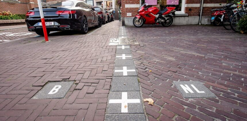
Baarle destroys that image. The Belgian-Dutch border twists and turns through the town. It crosses roads, gardens, sidewalks and properties. In some places, the border can change countries several times within a short distance.
Instead of relying on fences or walls, the town marks the boundary with special paving stones and metal plates embedded in the streets.
House numbers can also carry Belgian or Dutch flags, helping residents identify which country their property belongs to.
So, while you may technically be crossing an international border, the experience can feel remarkably ordinary.
You could simply be walking to a shop.
Imagine Having a Border in Your House
Perhaps the strangest part of Baarle is that the border does not stop at people’s front gardens. It can actually pass through buildings.
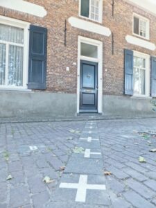
There are properties where one section of the building is in Belgium while another section is in the Netherlands. In one particularly famous house on Loveren, the international border runs directly through the front door. The property consequently has both a Belgian and a Dutch house number.
The Belgian side is identified with one number, while the Dutch side has another.
This creates an almost unbelievable situation: the same house can technically exist in two countries at once.
The town even developed a practical solution for determining where residents officially live.
The “Front Door Rule”
When a building crosses the border, authorities need to determine which country the occupants legally belong to.
Baarle has a simple but unusual answer: the front door matters.
Under the so-called front door rule, the country in which the front door is located determines where the residents are officially registered. The same principle can affect which country supplies utilities such as electricity and water.
But one particular house makes even this rule complicated.
Because its front door itself sits on the border, the property has both Belgian and Dutch house numbers.
It is an extraordinary example of how a centuries-old territorial arrangement can affect something as ordinary as someone’s home address.
How Did Such a Strange Border Come About?
The answer goes back hundreds of years.
The foundations of Baarle’s unusual territorial arrangement were laid in 1198, during a dispute involving the Count of Holland and the Duke of Brabant over control of the region around Breda.
Different pieces of land ended up under different forms of authority. Some areas were controlled by the Duke of Brabant, while others became associated with the Barony of Breda and, later, the Nassau family. Over generations, these separate landholdings created the complicated territorial pattern that eventually became the Baarle enclaves.
What is remarkable is that the medieval divisions were not completely erased by later political changes. Instead, they survived through centuries of wars, political transformations and changing borders.
When Belgium and the Netherlands Became Separate Countries
The situation became even more complicated when the political map of Europe changed.
Following Belgium’s independence from the Netherlands in 1830, the two countries needed to establish an official international boundary.
But Baarle was a problem.
Officials discovered that the territory could not easily be divided with one simple continuous line because the old land divisions were already deeply intertwined. Historical records identifying which individual parcels belonged to which authority became important in determining the border. The enclave boundaries were eventually recognized as official national borders in 1995.
That means the bizarre lines people can see today are not merely historical curiosities or symbolic markings. They represent genuine international boundaries.
Two Countries, One Community
Despite having one of the strangest borders on Earth, Baarle does not feel like a divided war zone.
Quite the opposite.
People live their everyday lives alongside the border.
The area has two municipal authorities, two mayors and two schools, yet residents share the same town and interact across the border routinely.
For locals, crossing the boundary can be so normal that it barely feels like crossing into another country.
For visitors, however, it can be astonishing.
A short walk through town can involve crossing between Belgium and the Netherlands multiple times.
One of the Smallest Enclaves in the World
Baarle’s enclaves are not all large.
Some are remarkably tiny.
One Belgian enclave, H7, is described by Baarle’s tourism authorities as the world’s smallest enclave. It covers only about 2,469 square metres roughly the size of one and a half houses and parts of surrounding gardens. The border through this tiny enclave creates one of Baarle’s most photographed sights because it passes through the middle of a front door.
Other enclaves are also unusually shaped, with some resembling narrow strips or irregular patches of land. The result is a map that looks less like a conventional national boundary and more like pieces of a jigsaw puzzle.
Baarle’s border is more than a tourist attraction.
It is a living reminder of how history can shape geography.
Modern countries are often imagined as carefully designed territories, but many borders are the products of centuries of wars, treaties, marriages, land ownership and political compromises.
Baarle demonstrates what happens when those historical arrangements survive instead of being replaced by a clean modern boundary.
The result is a place where medieval land divisions still influence modern addresses, administration and daily life.
A Border You Can Walk Across Without Noticing
Perhaps the strangest thing about Baarle is how ordinary the border can feel.
There is no dramatic checkpoint separating the two countries in the middle of town.
Instead, you might see a line running across the pavement.
You step over it.
And suddenly, you’re in another country.
Take a few more steps and you may be back in the first one.
In Baarle, the border isn’t just something you see on a map. It is part of the streets, the buildings and the lives of the people who live there.
And that is what makes this small town between Belgium and the Netherlands one of the world’s most fascinating geographical mysteries.